So you need to know the range of declinations over these cycles, you need to know your latitude, and then you can calculate the range of azimuths that will occur for moonrise and moonset at your location, and you can also calculate the minumum elevation of the moon for any particular azimuth. Once you know this information, you can do a site survey of your QTH and the optimal location for your dish will become clear.
If you wish, you can read a bit about lunar declination here.
But you don't need to read about lunar declination if you don't wish to. I've created a spreadsheet that will give you all the information that you need to figure out where to place your dish once you've done a site survey for your QTH. You can download the spreadsheet here.
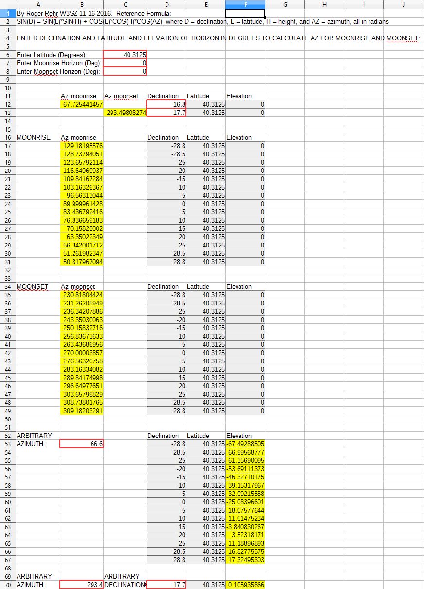
An illustration of that spreadsheet is below. It is based on the equation sin(D) = sin(L)*sin(H) + cos(L)*cos(H)*cos(AZ) where D = Declination, L = latitude, H = Height, and AZ = Azimuth, all in radians.
Near the top of the spreadsheet you enter your latitude in decimal degrees, as well as an estimation of the elevation of the horizon in degrees for both moonrise and moonset. I generally begin with these two elevations set to zero; they can be adjusted once you see the range of azimuths subtended by moonrise and moonset and then survey your site over that range of azimuths to determine your horizon's actual elevation over that range of azimuths.
Just below that section of the spreadsheet are two cells where you can enter the declination for moonrise and moonset and then see the azimuth for moonrise and moonset for those declination values. This section was used by me when I was checking the accuracy of the spreadsheet. This section is not needed for siting your array/dish, and you can ignore it.
Once you have, as described above, filled in the cells for your latitude and the estimated elevation of the horizon at moonrise and moonset, then the azimuth for moonrise and the azimuth for moonset will be calculated for representative declination values from the greatest possible negative declination value to the greatest possible positive declination value. The cells containing the results for these calculated azimuth values are colored yellow and displayed next to the headings "MOONRISE" and "MOONSET", respectively: